Hey fellow preppers! Interested in how to predict the weather? If you’re living in New Zealand you know how it works, one minute you’re basking in the sunshine, and the next, you’re caught in a sudden downpour. It’s part of the charm, but also a challenge, especially when you’re trying to stay prepared for anything Mother Nature might throw your way.
In this blog post, I’m going to share some of the best ways I’ve found to predict the weather. Whether you’re planning a multi-day hike, prepping your homestead, or just curious about what the skies are up to, these tips will help you stay one step ahead of the elements.
Understanding New Zealand’s Climate Zones
New Zealand’s weather varies a lot from place to place, so knowing the climate zones can help you predict the weather better. Here’s a quick rundown of the main regions:
Starting in the north, Northland and Auckland have a subtropical climate with warm, humid summers and mild winters. High humidity often signals incoming rain, and the North west winds can bring hot, dry conditions that might quickly change to wet and stormy.
Moving down to Wellington and the South Island’s West Coast, you’ll find a temperate maritime climate characterized by frequent rainfall year-round. Wellington, also known as the “Windy City,” is especially known for its rapid wind changes. A shift to southerly winds usually brings cooler, wetter weather, so keep an eye on wind direction.
In Central Otago, the climate is continental, with hot, dry summers and cold winters. Here, clear skies at night during summer can lead to very cold mornings. Be prepared for significant temperature swings, as it can be hot during the day and chilly at night.
Fiordland and the Southern Alps experience a climate of high rainfall and cooler temperatures. This area is one of the wettest places in the world, so you can expect frequent rain and sudden weather changes. Thick, low clouds forming over the mountains are often a sign that rain is imminent.
Observing Natural Indicators
Nature provides numerous signs that can help predict weather changes:
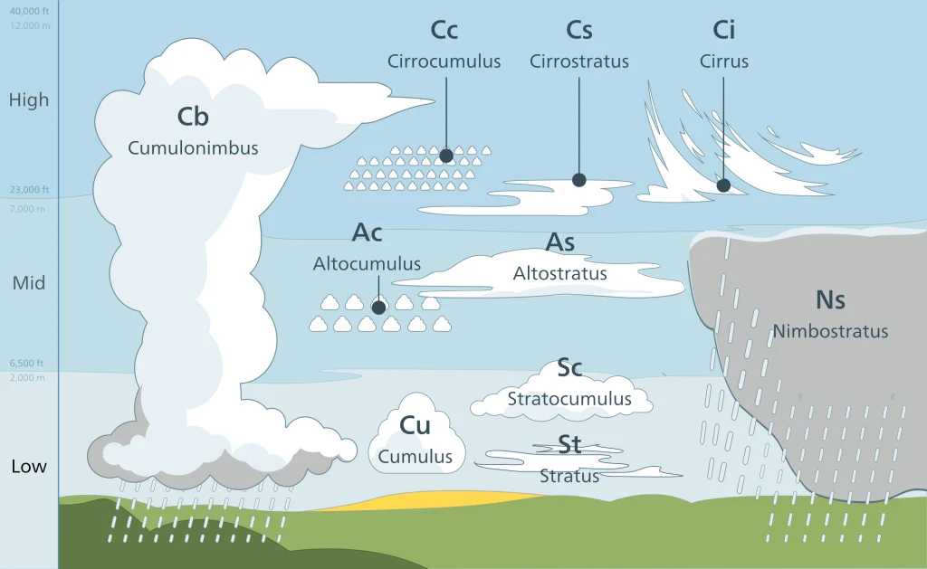
Observing Cloud Patterns
Clouds are one of the best natural indicators of upcoming weather changes. By understanding different types of clouds, you can make more accurate predictions.
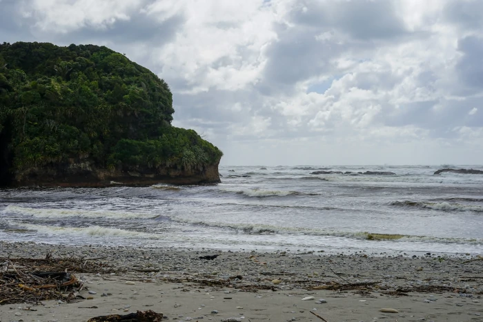
Copyright: Valentin de Bruyn
Cirrus Clouds:
These high, wispy clouds are usually seen during fair weather. However, if they start to thicken and cover more of the sky, they can indicate a change in the weather within the next 24-48 hours. In New Zealand, cirrus clouds moving in from the west often mean that a front is approaching.
Cumulus Clouds:
These fluffy, white clouds with flat bases are a sign of fair weather. However, if they grow larger and start to develop towering structures, known as cumulonimbus clouds, they can lead to thunderstorms, heavy rain, or even hail. This is especially common in the summer months.
Altostratus Clouds:
These low, gray clouds cover the sky like a blanket and usually bring overcast conditions and light rain or drizzle. In areas like Wellington and the South Island’s West Coast, stratus clouds are a common sight, often indicating persistent wet weather.
Cumulonimbus Clouds:
These are the towering, thunderstorm clouds that can bring severe weather, including heavy rain, lightning, thunder, and even hail. If you see these clouds forming, it’s a good idea to seek shelter and be prepared for a storm.
Nimbostratus Clouds:
Thick, dark clouds that cover the sky and bring continuous, steady rain. In regions with high rainfall like Fiordland and the Southern Alps, these clouds are common and often signal long periods of rain.
By watching the sky and understanding these cloud patterns, you can get a good sense of what the weather might do next. Here you can find out more about Observing the Clouds.
Reading Wind Directions
North west Winds:
These winds come from the northwest and are warm and dry, often signaling good weather in the north but can turn wet and stormy as they move south. In regions like Canterbury, nor’west winds can bring a phenomenon known as the “north wester,” which is a warm, dry wind that descends from the Southern Alps. While it can bring pleasant weather initially, it often precedes a cold front, bringing rain and cooler temperatures.
Southerly Winds:
Southerly winds typically bring cold, wet conditions, especially in winter. These winds come from the Antarctic region, carrying cold air up through the country. In Wellington, known for its strong and frequent winds, a sudden shift to a southerly wind usually means a cold front is coming, bringing rain and cooler temperatures. Southerly changes can be abrupt and severe, often dropping temperatures significantly in a short period.
Westerly Winds:
Westerly winds bring moisture-laden air from the Tasman Sea, often resulting in rain, especially on the west coast of the South Island. These winds are common and can lead to persistent wet weather in regions like Fiordland and the West Coast, where the mountains cause the moist air to rise and cool, leading to heavy precipitation.
Utilizing Technological Tools
In addition to natural indicators, technological tools are invaluable for predicting the weather. Here are some key tools and resources you can use:
Weather Apps:
Smartphone weather apps like MetService NZ, Weather Underground, and Windy provide up-to-date weather forecasts, radar images, and severe weather alerts. These apps use data from weather stations and satellites to give accurate predictions. MetService NZ, in particular, offers detailed forecasts tailored for different regions in New Zealand, including severe weather warnings and real-time updates.
Weather Websites:
Websites like MetService, WeatherWatch, and NIWA provide comprehensive weather information, including detailed forecasts, weather maps, and climate data. MetService offers marine forecasts, mountain weather updates, and specialized reports for outdoor activities. WeatherWatch provides additional insights into long-range forecasts and weather patterns affecting New Zealand.
Radar and Satellite Imagery:
Radar images show real-time precipitation, helping you track rain, snow, and storms as they move. Satellite images provide a broader view of weather systems, showing cloud cover and storm development. Websites like MetService and Windy offer interactive radar and satellite maps that allow you to see weather patterns in real-time.
Barometer:
A barometer is a handy tool for predicting changes in the weather by measuring atmospheric pressure. When the pressure drops, it often signals that a storm or rainy weather is approaching, as lower pressure is typically associated with unsettled conditions. Conversely, rising pressure usually indicates clear skies and stable weather. For preppers in New Zealand, using a barometer can be particularly useful in regions where weather can change quickly. By keeping an eye on pressure trends, you can anticipate weather changes and better prepare for upcoming conditions, making your outdoor activities and preparedness plans more effective.
Be prepared for all conditions